


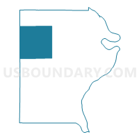
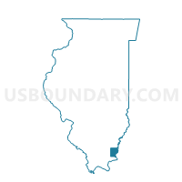
NORTH FORK Voting District, Gallatin County, Illinois
About
Outline

Summary
| Unique Area Identifier | 570985 |
| Name | NORTH FORK Voting District |
| County | Gallatin County |
| State | Illinois |
| Area (square miles) | 36.78 |
| Land Area (square miles) | 36.58 |
| Water Area (square miles) | 0.20 |
| % of Land Area | 99.45 |
| % of Water Area | 0.55 |
| Latitude of the Internal Point | 37.81920670 |
| Longtitude of the Internal Point | -88.32014640 |
Maps

Graphs
Select a template below for downloading or customizing gragh for NORTH FORK Voting District, Gallatin County, Illinois


Neighbors
Neighoring Voting District (by Name) Neighboring Voting District on the Map
- ASBURY Voting District, Gallatin County, IL
- COTTAGE 1 Voting District, Saline County, IL
- ELDORADO 1 Voting District, Saline County, IL
- EQUALITY Voting District, Gallatin County, IL
- GOLD HILL 1 Voting District, Gallatin County, IL
- OMAHA Voting District, Gallatin County, IL
- RECTOR 1 Voting District, Saline County, IL
- RIDGWAY 1 Voting District, Gallatin County, IL
Top 10 Neighboring County Subdivision (by Population) Neighboring County Subdivision on the Map
- East Eldorado township, Saline County, IL (5,906)
- Gold Hill township, Gallatin County, IL (1,708)
- Ridgway township, Gallatin County, IL (937)
- Equality township, Gallatin County, IL (849)
- Omaha township, Gallatin County, IL (499)
- North Fork township, Gallatin County, IL (408)
- Cottage township, Saline County, IL (219)
- Asbury township, Gallatin County, IL (105)
- Rector township, Saline County, IL (65)
Top 10 Neighboring Place (by Population) Neighboring Place on the Map
Top 10 Neighboring Unified School District (by Population) Neighboring Unified School District on the Map
- Eldorado Community Unit School District 4, IL (7,232)
- Gallatin Community Unit School District 7, IL (5,268)